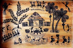
Close

    Introduction

    About Dadra & Nagar Haveli

    Dadra Nagar Haveli, endowed with nature’s munificence, it’s a land of spell-binding beauty. Green forests, winding rivers, unimaginable waterfronts, gentle gurgle of streams, distant dotting mountain ranges, a gorgeous kaleidoscope of flora and fauna. Owing to its serenity and quaint sylvan surroundings, this district is a heaven for those who hunt around for a tranquil holiday.

    In order to keep the English at bay and to enlist their support against the Mughals, the Marathas made friends with the Portuguese and signed a treaty in 1779. According to this historic treaty of friendship, the Maratha-Peshwa agreed that the Portuguese will be allowed to collect revenue from Dadra and Nagar Haveli which consisted of 72 villages, then known as parganas in compensation for their loss of a warship called “Santanaâ” which had earlier been captured by the Marathas but not surrendered to the Portuguese in spite of their many entreaties. These territories were earlier ruled by the Koli chiefs who were defeated by the Hindu kings of Jawhar and Ramnagar. The Marathas conquered and annexed these territories to their kingdom. The area of Dadra  Nagar Haveli spread over 491.00 sq.kms landlocked between Gujarat in North and Maharashtra in South was liberated from Portuguese Rulers by people themselves on 2nd August 1954. The union territory was merged with the neighbouring union territory of Daman and Diu to form the new union territory of Dadra and Nagar Haveli and Daman and Diu on January 26, 2020. The territory of Dadra and Nagar Haveli then became one of the three districts of the new union territory, as the Dadra and Nagar Haveli District.

    History of Dadra and Nagar Haveliabout photo

    The  Portuguese occupied  Dadra and  Nagar  Haveli between  1783  and 1785 and ruled it till its liberation in 1954. The regime was marked by rapacity and corruption on the part of  Government and its officials,  exploitation of the local  Tribal  Population by a  handful  Sahukars  (money lenders)  and total indifference to the welfare of the people.  About  170  years of  Portuguese rule was brought to an end on  2  August  1954  by the volunteers of  Goa parties acting in close cooperation with the local inhabitants.  After its liberation,  the administration of the territory was carried on by an  Administrator with an Advisor to advise him on all administrative matters and soon steps were taken to associate the local people in the administration by the creation of  Varistha Panchayat and Group Panchayat.

    On  12th June  1961,  the  Varistha  Panchayat unanimously passed a resolution for integration with the  Indian  Union.  On  11.08.1961,  the territory became nationally united by the  Dadra and  Nagar  Haveli  Act  1961  (No.35  of 1961) passed by the Parliament. Consequently, the free Dadra & Nagar Haveli Administration was succeeded by a formal statutory Administration headed by an  Administrator,  Dadra and  Nagar  Haveli comprising of  72  villages and one town Statutory and 5 Census Town from a single district and single taluka as Union Territory. The union territory was merged with the neighbouring union territory of Daman and Diu to form the new union territory of Dadra and Nagar Haveli and Daman and Diu on January 26, 2020. The territory of Dadra and Nagar Haveli then became one of the three districts of the new union territory, as the Dadra and Nagar Haveli District.


    About Daman

    The ex-Portuguese enclave of Daman (Damao) is a world of its own. It is a paradise for travellers searching for peace, solitude and serenity. The charm of this place lies in its fine forts and churches, in which you can get a whiff of Portuguese preeminence. This quaint union territory had a serendipitous discovery too. The story goes like this. The first Portuguese Captain Diogo de Mello, while on his way to Ormuz, met with a violent cyclone, and got lost. When all his hopes were gone, he suddenly found himself at the Daman coast. Since then, Daman has been a destination for the wanderer who craves to be lost and found.

    The beauty of the Union Territory is such that it was once known as Kalana Pavri or Lotus of Marshlands. A laid back little town, Daman is divided by the Damanganga river and emanates a charm that’s whimsically untamed, but definitely not cruel.

    History of Damandamanabout

    The District of Daman is known to have formed part of the country known as Lata which was one the seven divisions of the Aparant or Konkan Vishaya, between 2nd Century B.C. to 13th Century A.D. The Daman District is included in the intervening region and therefore must have formed part of the Mauryan empire at least at the time of Ashoka. After the Mauryan power was weakened, the district was under the rule of Satkarni I, the Satavahana ruler at the end of 2nd Century B.C. After that, during the 1st Century A.D., the District of Daman seemed to have been ruled by Kshaharatas who were the provincial governors i.e Kshatrapas under the Kushana emperors. During A.D. 125, Satkarni drove away from the Kshaharatas and ruled the districts. But the Satavahana rule was shortlived. The Kshaharatas of Ujjain re-conquered the district by about A.D 150 from the Satavahana ruler Satakarni and Daman District again passed under the rule of Kshaharatas of Ujjain till A.D. 249. After the Kshatrapas, the district was ruled by the Abhir Kings till A.D. 416.

    After the rule of Abhir kings, the district was under the rule of Traikutakas during the 5th Century A.D. who were the feudatories of the Abhiras. By A.D. 500, the Traikutaka power seems to have been destroyed by the Vakataka king Harishena. The District then was under the power of the Kalachuris of Mahishmati King Krishnaraja and his successors till A.D. 609. King Mangales of Chalukyas of Badami routed out the last king Budharaja of Kalachuris by about A.D. 609. The Chalukyas of Badami ruled the district till A.D. 671 and their descendants known as Lata or Navasari Chalukyas ruled from Navasarika, modern Navasari, on the bank of the river Purna to the

    north of Daman. They ruled independently as feudatories of the Badami Chalukyas of the Deccan. In the next eight centuries, Daman came under the control of a large number of Hindu kings and chieftains.

    Mahmud Shah Begada, Sultan of Gujarat, seems to have conquered fort Parnera on the river Par and port of Daman and levied tribute from Jagatshah in 1465. Naranshah who succeeded Jagatshah ruled from A.D. 1470 to 1500 and Dharmshah II from 1500 to 1531.

    Daman was acquired by the Portuguese from the Shah of Gujarat. They noticed the port of Daman for the first time in 1523. They attacked it several times and finally obtained it in 1559 by means of a treaty with the Shah. Thereafter, it was under the rule of Portuguese till its liberation in 1961.

    About Diu

    A beautiful blend of sun, sand and sea, Diu is a God’s gift to those in quest of a blessed land where the weary weight of this unintelligible world can, for a while, be lightened and the waking soul can hear the music of nature. This tiny island of breeze, beauty and serenity situated off the southern tip of the Saurashtra (Kathiawad) peninsula of Gujarat, lapped by the Arabian Sea, is a picture of calmness with superb beaches and fascinating history. Diu is a picturesque island situated in the Arabian Sea, just off the Southern Coast of Kathiawad Peninsula of Gujarat. A portion of Diu District is on the mainland which is named as Ghoghla. A small part of Diu known as Simbor is situated at a distance of 25 km. from Diu which is accessible through Gujarat.

    It is one of the most famous holiday destinations in the western part of the country. Within the 40 Sq.kms. area, this beautiful town has everything that a tourist looks for gentle winds, soft sands, inviting sea waters, historical monuments, coconut groves and exotic seafood.

    History of DiuDiu overview photo

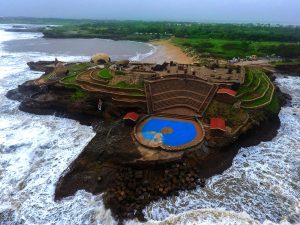
    The documented history of the District of Diu begins with the Maurya rule (c.322-220 B.C). Emperor Chandragupta Maurya had extended his supremacy over Saurashtra and had appointed Pushagupta as Governor of the province of Saurashtra with the Head-quarters in village Girnar near Junagadh. Yavanaraj Tushappa ruled over Saurashtra as Governor of Emperor Ashoka (c.273-237 B.C.). Emperor Ashoka had sent Yavana Thero named Dhammarakhito as an evangelist to the western seaboard including Diu. His grandson Samprati (c.229-220 B.C.) seems to have ruled over Saurashtra from Ujjain. He propagated Jainism and erected many Jain Temples. The Jain traditions from Diu seem to belong to this period.

    The District seems to be under the rule of Indo-Greek kings Eukratides (c.171- 150 B.C. ), Meanandar (c.115 to 90 B.C.) and Appollodotes II of the 1st Century B.C. No historical information is available for the period of 150 years from the 1st Century B.C. to about A.D. 50. During the A.D. 1st Century, the district seems to have been ruled by Kshaharatas who had established their rule over the western part of India including Saurashtra. For more than the next thousand years, Diu formed part of the kingdoms of dynasties that ruled over western India including Gujarat.

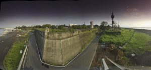
    The last king of the Vaja dynasty ruler of Somnath Patan ruled over Diu in the first decade of the fifteenth century. Thereafter, Diu came under the control of the Muslims Sultans of Gujarat who seems to have ruled Diu for the next one and a half centuries. Early in 1535, the Portuguese Governor De Cunha had led his expedition for the capture of the town in Diu but was defeated by the Sultan. However, around that period, the Gujarat Sultan Bahadur Shah‟s kingdom was overwhelmed by Mughal invasion. Pressed by Mughal king Humayun on one side and the Portuguese at the gates of Diu, Bahadur Shah entered into a treaty with Nuno da Cunha on October 25, 1535, who agreed to assist Bahadur Shah against his enemy by land and sea. In turn, he received permission to construct a fortress at Diu and a site was granted for this purpose in the harbour. After the Mughal danger was receded, the Shah of Gujarat realized his mistake in allowing the Portuguese to construct the fort. Finally, Diu was conquered by the Portuguese in 1546 who ruled there till 1961. Liberated on 19th December 1961 from Portuguese; became a part of the U.T. of Goa, Daman and Diu under Government of India. After Statehood of Goa on 30th May 1987, Daman and Diu became a separate U.T.

    The town of Diu was an important port of trade routes of the Arabian sea of Indian Ocean.

    Due to its strategic importance, there was a Battle of Diu in 1509 between Portugal and a combined force of Turkey, Egypt, Venice, the Republic of Ragusa (now known as Dubrovnik) and the Sultan of Gujarat, Mahmud Begada. In 1513, the Portuguese tried to establish an outpost there, but negotiations were unsuccessful. There were failed attempts by Diogo Lopes de Sequeira in 1521, Nuno da Cunha in 1523

    In 1535 Bahadur Shah, the Sultan of Gujarat concluded a defensive alliance with the Portuguese against the Mughal emperor Humayun and allowed the Portuguese to construct the Diu Fort and maintain a garrison on the island. The alliance quickly unravelled, and attempts by the Sultans to oust the Portuguese from Diu between 1537 and 1546 failed.

    Diu was so fortified so that it could withstand the later attacks of the Arabs of Muscat and the Dutch in the late 17th century. From the 18th century, Diu declined in strategic importance, due to the development of Bombay.

    Diu remained in the possession of the Portuguese from 1535 until 1961, when it was liberated under Operation Vijay. The island was occupied by the Indian military on 19 December 1961. The Battle of Diu involved overwhelming land, sea and airstrikes on the enclave for 48 hours until the Portuguese garrison there surrendered. It was declared union territory of India, Goa, Daman, and Diu. Goa separated as a state in 1987 thus it became a part of the Union Territory of Daman and Diu.